|
|
|||||||||||||||||
| Point ID: 8619 | Downloads | Plots | Site Data | Code: 11245 |
|
|
|||||||||||||||||
| Download | |
|---|---|
| Site Descriptor Information | Site Time Series Data |
| Link to all available data | |
| View: | Time Series | All |
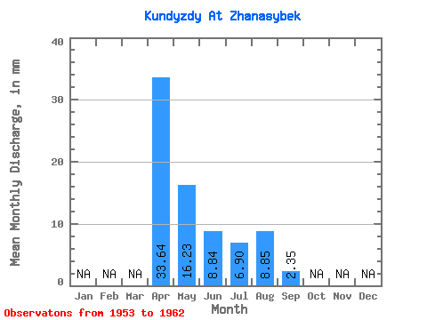
| Units: | m3/s |
| Statistic | Jan | Feb | Mar | Apr | May | Jun | Jul | Aug | Sep | Oct | Nov | Dec | Annual |
|---|---|---|---|---|---|---|---|---|---|---|---|---|---|
| Mean | 33.64 | 16.21 | 8.83 | 6.88 | 8.84 | 2.34 | |||||||
| Standard Deviation | 28.19 | 16.30 | 9.41 | 7.23 | |||||||||
| Min | 9.78 | 1.47 | 1.05 | 2.24 | 8.84 | 2.34 | |||||||
| Max | 74.42 | 49.17 | 26.85 | 17.68 | 8.84 | 2.34 | |||||||
| Coefficient of Variation | 0.84 | 1.00 | 1.07 | 1.05 |
 Return to R-Arctic Net Home Page