|
|
|||||||||||||||||
| Point ID: 8614 | Downloads | Plots | Site Data | Code: 11232 |
|
|
|||||||||||||||||
| Download | |
|---|---|
| Site Descriptor Information | Site Time Series Data |
| Link to all available data | |
| View: | Time Series | All |
| Units: | mm |
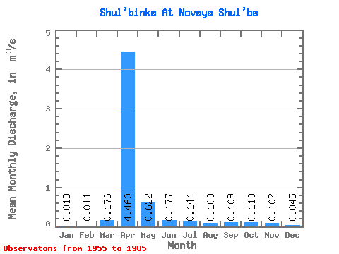
| Statistic | Jan | Feb | Mar | Apr | May | Jun | Jul | Aug | Sep | Oct | Nov | Dec | Annual |
|---|---|---|---|---|---|---|---|---|---|---|---|---|---|
| Mean | 0.02 | 0.01 | 0.18 | 4.46 | 0.62 | 0.18 | 0.14 | 0.10 | 0.11 | 0.11 | 0.10 | 0.04 | 0.47 |
| Standard Deviation | 0.06 | 0.04 | 0.33 | 4.34 | 0.46 | 0.16 | 0.22 | 0.12 | 0.11 | 0.08 | 0.11 | 0.08 | 0.31 |
| Min | 0.00 | 0.00 | 0.00 | 0.51 | 0.06 | 0.00 | 0.00 | 0.00 | 0.00 | 0.00 | 0.00 | 0.00 | 0.13 |
| Max | 0.25 | 0.17 | 1.20 | 20.50 | 1.74 | 0.67 | 1.20 | 0.64 | 0.62 | 0.27 | 0.48 | 0.31 | 1.12 |
| Coefficient of Variation | 3.15 | 3.29 | 1.90 | 0.97 | 0.74 | 0.88 | 1.54 | 1.20 | 1.04 | 0.70 | 1.09 | 1.81 | 0.67 |
 Return to R-Arctic Net Home Page