|
|
|||||||||||||||||
| Point ID: 8614 | Downloads | Plots | Site Data | Code: 11232 |
|
|
|||||||||||||||||
| Download | |
|---|---|
| Site Descriptor Information | Site Time Series Data |
| Link to all available data | |
| View: | Time Series | All |
| Units: | m3/s |
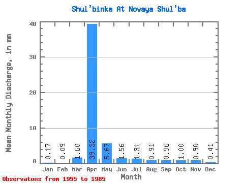
| Statistic | Jan | Feb | Mar | Apr | May | Jun | Jul | Aug | Sep | Oct | Nov | Dec | Annual |
|---|---|---|---|---|---|---|---|---|---|---|---|---|---|
| Mean | 0.17 | 0.09 | 1.60 | 39.32 | 5.67 | 1.56 | 1.31 | 0.91 | 0.96 | 1.01 | 0.90 | 0.41 | 50.25 |
| Standard Deviation | 0.55 | 0.30 | 3.04 | 38.29 | 4.19 | 1.37 | 2.03 | 1.09 | 1.00 | 0.70 | 0.98 | 0.73 | 33.62 |
| Min | 0.00 | 0.00 | 0.00 | 4.50 | 0.57 | 0.00 | 0.00 | 0.00 | 0.00 | 0.00 | 0.00 | 0.00 | 14.22 |
| Max | 2.28 | 1.42 | 10.93 | 180.74 | 15.85 | 5.91 | 10.93 | 5.83 | 5.47 | 2.46 | 4.24 | 2.83 | 120.50 |
| Coefficient of Variation | 3.15 | 3.29 | 1.90 | 0.97 | 0.74 | 0.88 | 1.54 | 1.20 | 1.04 | 0.70 | 1.09 | 1.81 | 0.67 |
 Return to R-Arctic Net Home Page