|
|
|||||||||||||||||
| Point ID: 8612 | Downloads | Plots | Site Data | Code: 11229 |
|
|
|||||||||||||||||
| Download | |
|---|---|
| Site Descriptor Information | Site Time Series Data |
| Link to all available data | |
| View: | Time Series | All |
| Units: | mm |
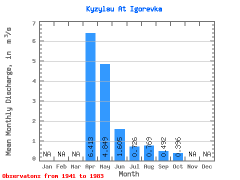
| Statistic | Jan | Feb | Mar | Apr | May | Jun | Jul | Aug | Sep | Oct | Nov | Dec | Annual |
|---|---|---|---|---|---|---|---|---|---|---|---|---|---|
| Mean | 6.41 | 4.85 | 1.60 | 0.73 | 0.77 | 0.49 | 0.40 | ||||||
| Standard Deviation | 1.97 | 4.02 | 1.22 | 0.52 | 0.94 | 0.36 | 0.25 | ||||||
| Min | 3.54 | 0.61 | 0.14 | 0.12 | 0.07 | 0.07 | 0.11 | ||||||
| Max | 7.78 | 17.70 | 4.75 | 1.90 | 3.80 | 1.29 | 0.78 | ||||||
| Coefficient of Variation | 0.31 | 0.83 | 0.76 | 0.71 | 1.22 | 0.73 | 0.63 |
 Return to R-Arctic Net Home Page