|
|
|||||||||||||||||
| Point ID: 8612 | Downloads | Plots | Site Data | Code: 11229 |
|
|
|||||||||||||||||
| Download | |
|---|---|
| Site Descriptor Information | Site Time Series Data |
| Link to all available data | |
| View: | Time Series | All |
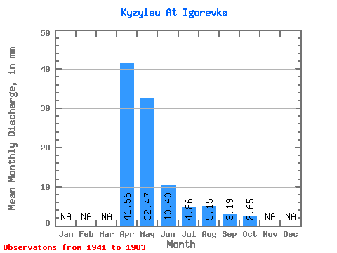
| Units: | m3/s |
| Statistic | Jan | Feb | Mar | Apr | May | Jun | Jul | Aug | Sep | Oct | Nov | Dec | Annual |
|---|---|---|---|---|---|---|---|---|---|---|---|---|---|
| Mean | 41.55 | 32.47 | 10.40 | 4.86 | 5.15 | 3.19 | 2.65 | ||||||
| Standard Deviation | 12.75 | 26.89 | 7.92 | 3.46 | 6.29 | 2.32 | 1.68 | ||||||
| Min | 22.94 | 4.08 | 0.91 | 0.80 | 0.45 | 0.42 | 0.74 | ||||||
| Max | 50.41 | 118.50 | 30.78 | 12.72 | 25.44 | 8.36 | 5.22 | ||||||
| Coefficient of Variation | 0.31 | 0.83 | 0.76 | 0.71 | 1.22 | 0.73 | 0.63 |
 Return to R-Arctic Net Home Page