|
|
|||||||||||||||||
| Point ID: 8604 | Downloads | Plots | Site Data | Code: 11214 |
|
|
|||||||||||||||||
| Download | |
|---|---|
| Site Descriptor Information | Site Time Series Data |
| Link to all available data | |
| View: | Time Series | All |
| Units: | mm |
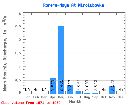
| Statistic | Jan | Feb | Mar | Apr | May | Jun | Jul | Aug | Sep | Oct | Nov | Dec | Annual |
|---|---|---|---|---|---|---|---|---|---|---|---|---|---|
| Mean | 0.57 | 2.49 | 0.33 | 0.09 | 0.04 | 0.04 | 0.27 | ||||||
| Standard Deviation | 0.13 | 6.60 | 0.41 | 0.06 | 0.02 | ||||||||
| Min | 0.47 | 0.04 | 0.02 | 0.01 | 0.02 | 0.04 | 0.27 | ||||||
| Max | 0.74 | 24.40 | 1.50 | 0.15 | 0.05 | 0.04 | 0.27 | ||||||
| Coefficient of Variation | 0.22 | 2.65 | 1.26 | 0.69 | 0.44 |
 Return to R-Arctic Net Home Page