|
|
|||||||||||||||||
| Point ID: 8604 | Downloads | Plots | Site Data | Code: 11214 |
|
|
|||||||||||||||||
| Download | |
|---|---|
| Site Descriptor Information | Site Time Series Data |
| Link to all available data | |
| View: | Time Series | All |
| Units: | m3/s |
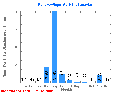
| Statistic | Jan | Feb | Mar | Apr | May | Jun | Jul | Aug | Sep | Oct | Nov | Dec | Annual |
|---|---|---|---|---|---|---|---|---|---|---|---|---|---|
| Mean | 17.67 | 79.42 | 10.09 | 2.94 | 1.25 | 1.23 | 8.33 | ||||||
| Standard Deviation | 3.90 | 210.43 | 12.76 | 2.04 | 0.56 | ||||||||
| Min | 14.50 | 1.44 | 0.62 | 0.35 | 0.64 | 1.23 | 8.33 | ||||||
| Max | 22.83 | 777.89 | 46.29 | 4.78 | 1.72 | 1.23 | 8.33 | ||||||
| Coefficient of Variation | 0.22 | 2.65 | 1.26 | 0.69 | 0.44 |
 Return to R-Arctic Net Home Page