|
|
|||||||||||||||||
| Point ID: 8590 | Downloads | Plots | Site Data | Code: 11178 |
|
|
|||||||||||||||||
| Download | |
|---|---|
| Site Descriptor Information | Site Time Series Data |
| Link to all available data | |
| View: | Time Series | All |
| Units: | mm |
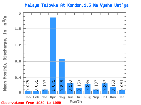
| Statistic | Jan | Feb | Mar | Apr | May | Jun | Jul | Aug | Sep | Oct | Nov | Dec | Annual |
|---|---|---|---|---|---|---|---|---|---|---|---|---|---|
| Mean | 0.08 | 0.06 | 0.10 | 1.87 | 0.85 | 0.27 | 0.15 | 0.23 | 0.11 | 0.26 | 0.16 | 0.09 | 0.35 |
| Standard Deviation | 0.06 | 0.03 | 0.05 | 0.54 | 0.55 | 0.23 | 0.10 | 0.28 | 0.04 | 0.16 | 0.10 | 0.07 | 0.11 |
| Min | 0.04 | 0.03 | 0.04 | 1.01 | 0.11 | 0.07 | 0.04 | 0.04 | 0.04 | 0.06 | 0.05 | 0.04 | 0.14 |
| Max | 0.23 | 0.14 | 0.18 | 2.64 | 1.66 | 0.71 | 0.34 | 0.92 | 0.15 | 0.55 | 0.30 | 0.22 | 0.51 |
| Coefficient of Variation | 0.81 | 0.54 | 0.48 | 0.29 | 0.65 | 0.84 | 0.67 | 1.19 | 0.32 | 0.61 | 0.60 | 0.75 | 0.32 |
 Return to R-Arctic Net Home Page