|
|
|||||||||||||||||
| Point ID: 8590 | Downloads | Plots | Site Data | Code: 11178 |
|
|
|||||||||||||||||
| Download | |
|---|---|
| Site Descriptor Information | Site Time Series Data |
| Link to all available data | |
| View: | Time Series | All |
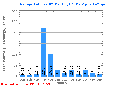
| Units: | m3/s |
| Statistic | Jan | Feb | Mar | Apr | May | Jun | Jul | Aug | Sep | Oct | Nov | Dec | Annual |
|---|---|---|---|---|---|---|---|---|---|---|---|---|---|
| Mean | 9.26 | 6.74 | 12.44 | 220.45 | 103.16 | 31.72 | 18.20 | 28.66 | 12.63 | 31.24 | 18.56 | 11.49 | 497.90 |
| Standard Deviation | 7.45 | 3.65 | 5.98 | 63.32 | 66.88 | 26.53 | 12.22 | 34.04 | 4.07 | 19.19 | 11.16 | 8.66 | 158.14 |
| Min | 4.26 | 3.00 | 4.26 | 119.00 | 13.39 | 8.25 | 4.87 | 4.87 | 4.71 | 7.30 | 5.66 | 4.87 | 194.93 |
| Max | 28.00 | 15.53 | 21.91 | 311.04 | 202.07 | 83.65 | 41.39 | 111.99 | 17.67 | 66.95 | 35.34 | 26.78 | 731.62 |
| Coefficient of Variation | 0.81 | 0.54 | 0.48 | 0.29 | 0.65 | 0.84 | 0.67 | 1.19 | 0.32 | 0.61 | 0.60 | 0.75 | 0.32 |
 Return to R-Arctic Net Home Page