|
|
|||||||||||||||||
| Point ID: 8586 | Downloads | Plots | Site Data | Code: 11170 |
|
|
|||||||||||||||||
| Download | |
|---|---|
| Site Descriptor Information | Site Time Series Data |
| Link to all available data | |
| View: | Time Series | All |
| Units: | mm |
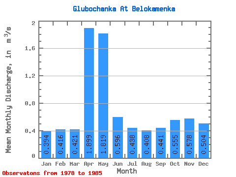
| Statistic | Jan | Feb | Mar | Apr | May | Jun | Jul | Aug | Sep | Oct | Nov | Dec | Annual |
|---|---|---|---|---|---|---|---|---|---|---|---|---|---|
| Mean | 0.39 | 0.42 | 0.42 | 1.90 | 1.82 | 0.60 | 0.44 | 0.41 | 0.44 | 0.56 | 0.58 | 0.50 | 0.71 |
| Standard Deviation | 0.12 | 0.12 | 0.11 | 0.35 | 1.97 | 0.23 | 0.15 | 0.12 | 0.13 | 0.16 | 0.09 | 0.09 | 0.19 |
| Min | 0.23 | 0.18 | 0.20 | 1.62 | 0.55 | 0.35 | 0.25 | 0.27 | 0.28 | 0.35 | 0.48 | 0.36 | 0.50 |
| Max | 0.57 | 0.55 | 0.55 | 2.63 | 6.50 | 0.99 | 0.78 | 0.67 | 0.67 | 0.78 | 0.70 | 0.62 | 1.05 |
| Coefficient of Variation | 0.31 | 0.28 | 0.27 | 0.18 | 1.08 | 0.39 | 0.35 | 0.29 | 0.30 | 0.28 | 0.15 | 0.17 | 0.27 |
 Return to R-Arctic Net Home Page