|
|
|||||||||||||||||
| Point ID: 8586 | Downloads | Plots | Site Data | Code: 11170 |
|
|
|||||||||||||||||
| Download | |
|---|---|
| Site Descriptor Information | Site Time Series Data |
| Link to all available data | |
| View: | Time Series | All |
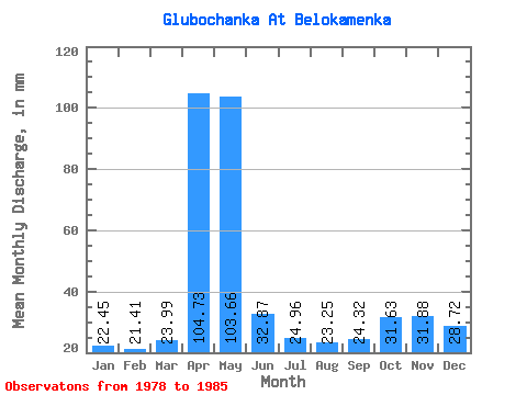
| Units: | m3/s |
| Statistic | Jan | Feb | Mar | Apr | May | Jun | Jul | Aug | Sep | Oct | Nov | Dec | Annual |
|---|---|---|---|---|---|---|---|---|---|---|---|---|---|
| Mean | 22.43 | 21.61 | 24.00 | 104.71 | 103.63 | 32.88 | 24.93 | 23.22 | 24.33 | 31.62 | 31.85 | 28.70 | 473.82 |
| Standard Deviation | 6.94 | 6.16 | 6.52 | 19.33 | 112.44 | 12.86 | 8.76 | 6.84 | 7.30 | 8.86 | 4.70 | 5.01 | 125.86 |
| Min | 13.11 | 9.35 | 11.40 | 89.34 | 31.34 | 19.30 | 14.24 | 15.38 | 15.44 | 19.94 | 26.47 | 20.51 | 338.54 |
| Max | 32.48 | 28.55 | 31.34 | 145.04 | 370.36 | 54.60 | 44.44 | 38.18 | 36.95 | 44.44 | 38.60 | 35.33 | 706.18 |
| Coefficient of Variation | 0.31 | 0.28 | 0.27 | 0.18 | 1.08 | 0.39 | 0.35 | 0.29 | 0.30 | 0.28 | 0.15 | 0.17 | 0.27 |
 Return to R-Arctic Net Home Page