|
|
|||||||||||||||||
| Point ID: 8565 | Downloads | Plots | Site Data | Code: 11104 |
|
|
|||||||||||||||||
| Download | |
|---|---|
| Site Descriptor Information | Site Time Series Data |
| Link to all available data | |
| View: | Time Series | All |
| Units: | mm |
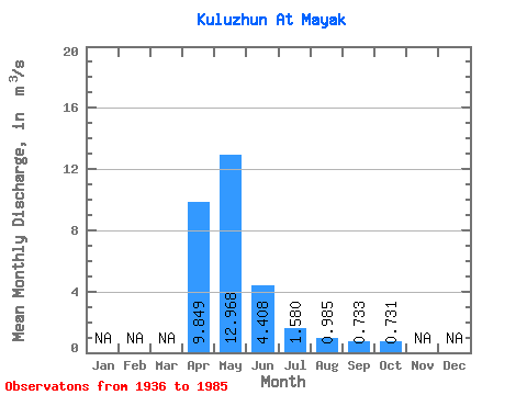
| Statistic | Jan | Feb | Mar | Apr | May | Jun | Jul | Aug | Sep | Oct | Nov | Dec | Annual |
|---|---|---|---|---|---|---|---|---|---|---|---|---|---|
| Mean | 9.85 | 12.97 | 4.41 | 1.58 | 0.98 | 0.73 | 0.73 | ||||||
| Standard Deviation | 10.63 | 10.88 | 4.25 | 1.08 | 1.14 | 0.39 | 0.58 | ||||||
| Min | 0.38 | 1.46 | 0.46 | 0.24 | 0.16 | 0.13 | 0.39 | ||||||
| Max | 39.20 | 47.40 | 24.40 | 4.52 | 7.18 | 1.92 | 2.00 | ||||||
| Coefficient of Variation | 1.08 | 0.84 | 0.96 | 0.69 | 1.16 | 0.53 | 0.79 |
 Return to R-Arctic Net Home Page