|
|
|||||||||||||||||
| Point ID: 8565 | Downloads | Plots | Site Data | Code: 11104 |
|
|
|||||||||||||||||
| Download | |
|---|---|
| Site Descriptor Information | Site Time Series Data |
| Link to all available data | |
| View: | Time Series | All |
| Units: | m3/s |
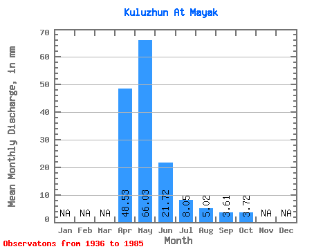
| Statistic | Jan | Feb | Mar | Apr | May | Jun | Jul | Aug | Sep | Oct | Nov | Dec | Annual |
|---|---|---|---|---|---|---|---|---|---|---|---|---|---|
| Mean | 48.53 | 66.02 | 21.72 | 8.04 | 5.01 | 3.61 | 3.72 | ||||||
| Standard Deviation | 52.37 | 55.38 | 20.93 | 5.52 | 5.83 | 1.91 | 2.93 | ||||||
| Min | 1.87 | 7.43 | 2.27 | 1.22 | 0.82 | 0.64 | 1.99 | ||||||
| Max | 193.17 | 241.32 | 120.24 | 23.01 | 36.56 | 9.46 | 10.18 | ||||||
| Coefficient of Variation | 1.08 | 0.84 | 0.96 | 0.69 | 1.16 | 0.53 | 0.79 |
 Return to R-Arctic Net Home Page