|
|
|||||||||||||||||
| Point ID: 8564 | Downloads | Plots | Site Data | Code: 11102 |
|
|
|||||||||||||||||
| Download | |
|---|---|
| Site Descriptor Information | Site Time Series Data |
| Link to all available data | |
| View: | Time Series | All |
| Units: | mm |
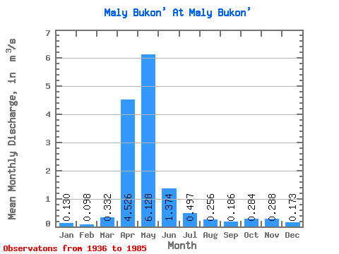
| Statistic | Jan | Feb | Mar | Apr | May | Jun | Jul | Aug | Sep | Oct | Nov | Dec | Annual |
|---|---|---|---|---|---|---|---|---|---|---|---|---|---|
| Mean | 0.13 | 0.10 | 0.33 | 4.53 | 6.13 | 1.37 | 0.50 | 0.26 | 0.19 | 0.28 | 0.29 | 0.17 | 1.17 |
| Standard Deviation | 0.06 | 0.05 | 0.57 | 3.48 | 5.16 | 1.23 | 0.47 | 0.24 | 0.14 | 0.28 | 0.23 | 0.12 | 0.63 |
| Min | 0.04 | 0.01 | 0.01 | 0.56 | 0.73 | 0.11 | 0.04 | 0.03 | 0.01 | 0.03 | 0.03 | 0.03 | 0.34 |
| Max | 0.26 | 0.17 | 2.44 | 14.70 | 26.90 | 5.26 | 2.60 | 1.20 | 0.59 | 1.34 | 0.89 | 0.48 | 2.95 |
| Coefficient of Variation | 0.47 | 0.50 | 1.72 | 0.77 | 0.84 | 0.90 | 0.95 | 0.95 | 0.77 | 0.98 | 0.79 | 0.69 | 0.54 |
 Return to R-Arctic Net Home Page