|
|
|||||||||||||||||
| Point ID: 8564 | Downloads | Plots | Site Data | Code: 11102 |
|
|
|||||||||||||||||
| Download | |
|---|---|
| Site Descriptor Information | Site Time Series Data |
| Link to all available data | |
| View: | Time Series | All |
| Units: | m3/s |
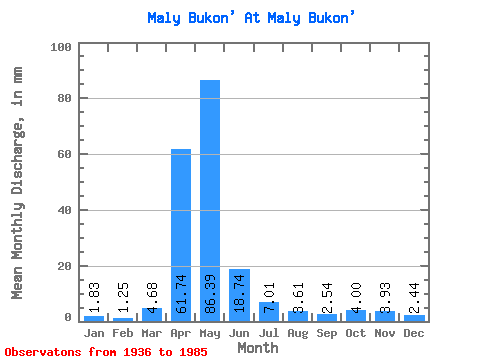
| Statistic | Jan | Feb | Mar | Apr | May | Jun | Jul | Aug | Sep | Oct | Nov | Dec | Annual |
|---|---|---|---|---|---|---|---|---|---|---|---|---|---|
| Mean | 1.84 | 1.26 | 4.67 | 61.75 | 86.38 | 18.74 | 7.01 | 3.61 | 2.53 | 4.00 | 3.93 | 2.44 | 193.76 |
| Standard Deviation | 0.86 | 0.63 | 8.05 | 47.43 | 72.70 | 16.82 | 6.67 | 3.42 | 1.94 | 3.92 | 3.09 | 1.68 | 105.07 |
| Min | 0.55 | 0.13 | 0.09 | 7.64 | 10.29 | 1.50 | 0.62 | 0.48 | 0.20 | 0.36 | 0.37 | 0.40 | 56.71 |
| Max | 3.67 | 2.18 | 34.40 | 200.54 | 379.15 | 71.77 | 36.65 | 16.91 | 8.06 | 18.89 | 12.14 | 6.76 | 489.73 |
| Coefficient of Variation | 0.47 | 0.50 | 1.72 | 0.77 | 0.84 | 0.90 | 0.95 | 0.95 | 0.77 | 0.98 | 0.79 | 0.69 | 0.54 |
 Return to R-Arctic Net Home Page