|
|
|||||||||||||||||
| Point ID: 8560 | Downloads | Plots | Site Data | Code: 11098 |
|
|
|||||||||||||||||
| Download | |
|---|---|
| Site Descriptor Information | Site Time Series Data |
| Link to all available data | |
| View: | Time Series | All |
| Units: | mm |
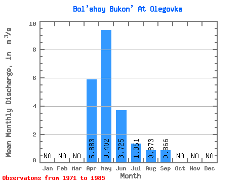
| Statistic | Jan | Feb | Mar | Apr | May | Jun | Jul | Aug | Sep | Oct | Nov | Dec | Annual |
|---|---|---|---|---|---|---|---|---|---|---|---|---|---|
| Mean | 5.88 | 9.40 | 3.73 | 1.35 | 0.87 | 0.87 | |||||||
| Standard Deviation | 3.74 | 6.26 | 2.68 | 0.99 | 0.63 | 0.53 | |||||||
| Min | 1.04 | 2.23 | 0.91 | 0.27 | 0.28 | 0.32 | |||||||
| Max | 12.60 | 23.20 | 10.60 | 3.36 | 2.61 | 1.87 | |||||||
| Coefficient of Variation | 0.64 | 0.67 | 0.72 | 0.73 | 0.72 | 0.62 |
 Return to R-Arctic Net Home Page