|
|
|||||||||||||||||
| Point ID: 8560 | Downloads | Plots | Site Data | Code: 11098 |
|
|
|||||||||||||||||
| Download | |
|---|---|
| Site Descriptor Information | Site Time Series Data |
| Link to all available data | |
| View: | Time Series | All |
| Units: | m3/s |
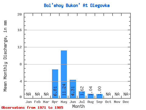
| Statistic | Jan | Feb | Mar | Apr | May | Jun | Jul | Aug | Sep | Oct | Nov | Dec | Annual |
|---|---|---|---|---|---|---|---|---|---|---|---|---|---|
| Mean | 6.81 | 11.24 | 4.31 | 1.61 | 1.04 | 1.00 | |||||||
| Standard Deviation | 4.33 | 7.48 | 3.10 | 1.18 | 0.75 | 0.62 | |||||||
| Min | 1.20 | 2.67 | 1.05 | 0.32 | 0.34 | 0.37 | |||||||
| Max | 14.58 | 27.74 | 12.27 | 4.02 | 3.12 | 2.16 | |||||||
| Coefficient of Variation | 0.64 | 0.67 | 0.72 | 0.73 | 0.72 | 0.62 |
 Return to R-Arctic Net Home Page