|
|
|||||||||||||||||
| Point ID: 856 | Downloads | Plots | Site Data | Code: 07EA005 |
|
|
|||||||||||||||||
| Download | |
|---|---|
| Site Descriptor Information | Site Time Series Data |
| Link to all available data | |
| View: | Time Series | All |
| Units: | mm |
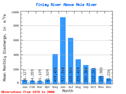
| Statistic | Jan | Feb | Mar | Apr | May | Jun | Jul | Aug | Sep | Oct | Nov | Dec | Annual |
|---|---|---|---|---|---|---|---|---|---|---|---|---|---|
| Mean | 56.13 | 44.36 | 40.11 | 61.51 | 409.45 | 917.32 | 633.50 | 339.41 | 260.36 | 213.26 | 109.98 | 75.23 | 263.38 |
| Standard Deviation | 8.36 | 5.82 | 6.44 | 17.91 | 169.93 | 184.32 | 144.68 | 89.91 | 71.75 | 68.63 | 21.75 | 15.71 | 25.91 |
| Min | 41.50 | 31.50 | 27.00 | 32.70 | 167.00 | 640.00 | 350.00 | 219.00 | 162.00 | 102.00 | 70.00 | 51.70 | 218.83 |
| Max | 72.20 | 54.90 | 58.50 | 115.00 | 686.00 | 1330.00 | 906.00 | 579.00 | 383.00 | 365.00 | 161.00 | 108.00 | 315.02 |
| Coefficient of Variation | 0.15 | 0.13 | 0.16 | 0.29 | 0.41 | 0.20 | 0.23 | 0.27 | 0.28 | 0.32 | 0.20 | 0.21 | 0.10 |
 Return to R-Arctic Net Home Page