|
|
|||||||||||||||||
| Point ID: 856 | Downloads | Plots | Site Data | Code: 07EA005 |
|
|
|||||||||||||||||
| Download | |
|---|---|
| Site Descriptor Information | Site Time Series Data |
| Link to all available data | |
| View: | Time Series | All |
| Units: | m3/s |
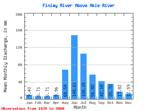
| Statistic | Jan | Feb | Mar | Apr | May | Jun | Jul | Aug | Sep | Oct | Nov | Dec | Annual |
|---|---|---|---|---|---|---|---|---|---|---|---|---|---|
| Mean | 9.39 | 6.76 | 6.71 | 9.96 | 68.53 | 148.61 | 106.03 | 56.81 | 42.18 | 35.70 | 17.82 | 12.59 | 519.52 |
| Standard Deviation | 1.40 | 0.89 | 1.08 | 2.90 | 28.44 | 29.86 | 24.22 | 15.05 | 11.62 | 11.49 | 3.52 | 2.63 | 51.10 |
| Min | 6.95 | 4.80 | 4.52 | 5.30 | 27.95 | 103.68 | 58.58 | 36.66 | 26.24 | 17.07 | 11.34 | 8.65 | 431.65 |
| Max | 12.08 | 8.37 | 9.79 | 18.63 | 114.82 | 215.46 | 151.64 | 96.91 | 62.05 | 61.09 | 26.08 | 18.08 | 621.39 |
| Coefficient of Variation | 0.15 | 0.13 | 0.16 | 0.29 | 0.41 | 0.20 | 0.23 | 0.27 | 0.28 | 0.32 | 0.20 | 0.21 | 0.10 |
 Return to R-Arctic Net Home Page