|
|
|||||||||||||||||
| Point ID: 8558 | Downloads | Plots | Site Data | Code: 11096 |
|
|
|||||||||||||||||
| Download | |
|---|---|
| Site Descriptor Information | Site Time Series Data |
| Link to all available data | |
| View: | Time Series | All |
| Units: | mm |
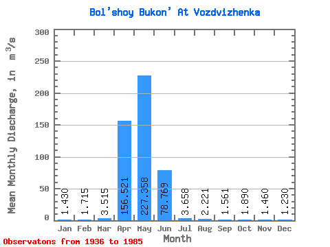
| Statistic | Jan | Feb | Mar | Apr | May | Jun | Jul | Aug | Sep | Oct | Nov | Dec | Annual |
|---|---|---|---|---|---|---|---|---|---|---|---|---|---|
| Mean | 1.43 | 1.71 | 3.52 | 156.52 | 227.36 | 78.77 | 3.66 | 2.22 | 1.56 | 1.89 | 1.46 | 1.23 | 7.46 |
| Standard Deviation | 0.21 | 0.74 | 0.93 | 184.38 | 275.85 | 102.32 | 4.15 | 2.77 | 1.27 | 1.02 | 0.54 | 0.28 | 2.96 |
| Min | 1.28 | 1.19 | 2.86 | 1.07 | 0.60 | 0.35 | 0.35 | 0.09 | 0.11 | 0.89 | 1.08 | 1.03 | 5.36 |
| Max | 1.58 | 2.24 | 4.17 | 689.00 | 921.00 | 475.00 | 18.60 | 15.00 | 4.79 | 4.06 | 1.84 | 1.43 | 9.56 |
| Coefficient of Variation | 0.15 | 0.43 | 0.26 | 1.18 | 1.21 | 1.30 | 1.13 | 1.25 | 0.81 | 0.54 | 0.37 | 0.23 | 0.40 |
 Return to R-Arctic Net Home Page