|
|
|||||||||||||||||
| Point ID: 8558 | Downloads | Plots | Site Data | Code: 11096 |
|
|
|||||||||||||||||
| Download | |
|---|---|
| Site Descriptor Information | Site Time Series Data |
| Link to all available data | |
| View: | Time Series | All |
| Units: | m3/s |
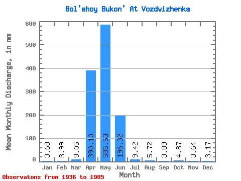
| Statistic | Jan | Feb | Mar | Apr | May | Jun | Jul | Aug | Sep | Oct | Nov | Dec | Annual |
|---|---|---|---|---|---|---|---|---|---|---|---|---|---|
| Mean | 3.68 | 4.02 | 9.05 | 390.10 | 585.45 | 196.32 | 9.42 | 5.72 | 3.89 | 4.87 | 3.64 | 3.17 | 226.41 |
| Standard Deviation | 0.55 | 1.74 | 2.38 | 459.52 | 710.31 | 255.02 | 10.69 | 7.12 | 3.15 | 2.63 | 1.34 | 0.73 | 89.98 |
| Min | 3.30 | 2.79 | 7.36 | 2.67 | 1.54 | 0.87 | 0.90 | 0.23 | 0.27 | 2.29 | 2.69 | 2.65 | 162.78 |
| Max | 4.07 | 5.25 | 10.74 | 1717.20 | 2371.57 | 1183.85 | 47.90 | 38.62 | 11.94 | 10.46 | 4.59 | 3.68 | 290.03 |
| Coefficient of Variation | 0.15 | 0.43 | 0.26 | 1.18 | 1.21 | 1.30 | 1.13 | 1.25 | 0.81 | 0.54 | 0.37 | 0.23 | 0.40 |
 Return to R-Arctic Net Home Page