|
|
|||||||||||||||||
| Point ID: 8555 | Downloads | Plots | Site Data | Code: 11091 |
|
|
|||||||||||||||||
| Download | |
|---|---|
| Site Descriptor Information | Site Time Series Data |
| Link to all available data | |
| View: | Time Series | All |
| Units: | mm |
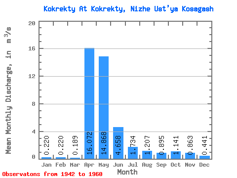
| Statistic | Jan | Feb | Mar | Apr | May | Jun | Jul | Aug | Sep | Oct | Nov | Dec | Annual |
|---|---|---|---|---|---|---|---|---|---|---|---|---|---|
| Mean | 0.22 | 0.22 | 0.19 | 16.07 | 14.87 | 4.66 | 1.73 | 1.21 | 0.90 | 1.14 | 0.86 | 0.44 | 3.64 |
| Standard Deviation | 0.17 | 0.16 | 0.12 | 5.89 | 10.38 | 3.57 | 1.53 | 1.44 | 0.78 | 0.90 | 0.56 | 0.33 | 1.53 |
| Min | 0.10 | 0.10 | 0.04 | 7.20 | 0.83 | 0.59 | 0.35 | 0.18 | 0.19 | 0.21 | 0.07 | 0.10 | 1.91 |
| Max | 0.49 | 0.44 | 0.33 | 24.40 | 39.10 | 14.10 | 5.81 | 5.53 | 2.65 | 2.72 | 1.51 | 1.01 | 5.02 |
| Coefficient of Variation | 0.78 | 0.71 | 0.62 | 0.37 | 0.70 | 0.77 | 0.88 | 1.19 | 0.87 | 0.79 | 0.65 | 0.75 | 0.42 |
 Return to R-Arctic Net Home Page