|
|
|||||||||||||||||
| Point ID: 8555 | Downloads | Plots | Site Data | Code: 11091 |
|
|
|||||||||||||||||
| Download | |
|---|---|
| Site Descriptor Information | Site Time Series Data |
| Link to all available data | |
| View: | Time Series | All |
| Units: | m3/s |
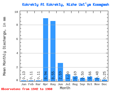
| Statistic | Jan | Feb | Mar | Apr | May | Jun | Jul | Aug | Sep | Oct | Nov | Dec | Annual |
|---|---|---|---|---|---|---|---|---|---|---|---|---|---|
| Mean | 0.13 | 0.12 | 0.11 | 8.94 | 8.54 | 2.59 | 1.00 | 0.69 | 0.50 | 0.66 | 0.48 | 0.25 | 24.66 |
| Standard Deviation | 0.10 | 0.08 | 0.07 | 3.28 | 5.97 | 1.99 | 0.88 | 0.83 | 0.43 | 0.52 | 0.31 | 0.19 | 10.39 |
| Min | 0.06 | 0.05 | 0.02 | 4.00 | 0.48 | 0.33 | 0.20 | 0.10 | 0.11 | 0.12 | 0.04 | 0.06 | 12.90 |
| Max | 0.28 | 0.23 | 0.19 | 13.57 | 22.47 | 7.84 | 3.34 | 3.18 | 1.47 | 1.56 | 0.84 | 0.58 | 34.01 |
| Coefficient of Variation | 0.78 | 0.71 | 0.62 | 0.37 | 0.70 | 0.77 | 0.88 | 1.19 | 0.87 | 0.79 | 0.65 | 0.75 | 0.42 |
 Return to R-Arctic Net Home Page