|
|
|||||||||||||||||
| Point ID: 8544 | Downloads | Plots | Site Data | Code: 11020 |
|
|
|||||||||||||||||
| Download | |
|---|---|
| Site Descriptor Information | Site Time Series Data |
| Link to all available data | |
| View: | Time Series | All |
| Units: | mm |
| Statistic | Jan | Feb | Mar | Apr | May | Jun | Jul | Aug | Sep | Oct | Nov | Dec | Annual |
|---|---|---|---|---|---|---|---|---|---|---|---|---|---|
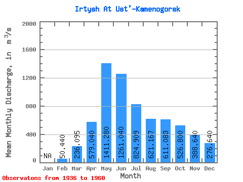
| Mean | 50.44 | 236.09 | 579.04 | 1411.28 | 1261.04 | 824.91 | 621.17 | 611.08 | 526.80 | 388.64 | 276.64 | ||
| Standard Deviation | 30.82 | 53.10 | 238.35 | 353.38 | 389.07 | 211.95 | 209.71 | 159.37 | 147.05 | 120.08 | 65.63 | ||
| Min | 2.00 | 144.00 | 90.00 | 694.00 | 494.00 | 399.00 | 130.00 | 314.00 | 210.00 | 224.00 | 178.00 | ||
| Max | 93.00 | 343.00 | 993.00 | 2000.00 | 1890.00 | 1180.00 | 973.00 | 972.00 | 886.00 | 697.00 | 445.00 | ||
| Coefficient of Variation | 0.61 | 0.23 | 0.41 | 0.25 | 0.31 | 0.26 | 0.34 | 0.26 | 0.28 | 0.31 | 0.24 |
 Return to R-Arctic Net Home Page