|
|
|||||||||||||||||
| Point ID: 8544 | Downloads | Plots | Site Data | Code: 11020 |
|
|
|||||||||||||||||
| Download | |
|---|---|
| Site Descriptor Information | Site Time Series Data |
| Link to all available data | |
| View: | Time Series | All |
| Units: | m3/s |
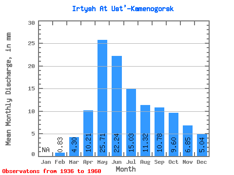
| Statistic | Jan | Feb | Mar | Apr | May | Jun | Jul | Aug | Sep | Oct | Nov | Dec | Annual |
|---|---|---|---|---|---|---|---|---|---|---|---|---|---|
| Mean | 0.84 | 4.30 | 10.21 | 25.71 | 22.23 | 15.03 | 11.32 | 10.78 | 9.60 | 6.85 | 5.04 | ||
| Standard Deviation | 0.51 | 0.97 | 4.20 | 6.44 | 6.86 | 3.86 | 3.82 | 2.81 | 2.68 | 2.12 | 1.20 | ||
| Min | 0.03 | 2.62 | 1.59 | 12.64 | 8.71 | 7.27 | 2.37 | 5.54 | 3.83 | 3.95 | 3.24 | ||
| Max | 1.54 | 6.25 | 17.51 | 36.44 | 33.33 | 21.50 | 17.73 | 17.14 | 16.14 | 12.29 | 8.11 | ||
| Coefficient of Variation | 0.61 | 0.23 | 0.41 | 0.25 | 0.31 | 0.26 | 0.34 | 0.26 | 0.28 | 0.31 | 0.24 |
 Return to R-Arctic Net Home Page