|
|
|||||||||||||||||
| Point ID: 8543 | Downloads | Plots | Site Data | Code: 11018 |
|
|
|||||||||||||||||
| Download | |
|---|---|
| Site Descriptor Information | Site Time Series Data |
| Link to all available data | |
| View: | Time Series | All |
| Units: | mm |
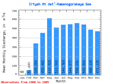
| Statistic | Jan | Feb | Mar | Apr | May | Jun | Jul | Aug | Sep | Oct | Nov | Dec | Annual |
|---|---|---|---|---|---|---|---|---|---|---|---|---|---|
| Mean | 51.64 | 339.25 | 453.46 | 610.92 | 511.50 | 540.77 | 544.58 | 558.23 | 543.50 | 488.12 | 471.12 | ||
| Standard Deviation | 27.44 | 103.14 | 269.94 | 192.81 | 94.72 | 83.99 | 96.50 | 106.02 | 92.43 | 106.70 | 153.81 | ||
| Min | 2.00 | 226.00 | 50.00 | 239.00 | 270.00 | 377.00 | 379.00 | 377.00 | 382.00 | 329.00 | 238.00 | ||
| Max | 90.00 | 657.00 | 919.00 | 968.00 | 741.00 | 747.00 | 738.00 | 802.00 | 768.00 | 724.00 | 847.00 | ||
| Coefficient of Variation | 0.53 | 0.30 | 0.59 | 0.32 | 0.18 | 0.15 | 0.18 | 0.19 | 0.17 | 0.22 | 0.33 |
 Return to R-Arctic Net Home Page