|
|
|||||||||||||||||
| Point ID: 8543 | Downloads | Plots | Site Data | Code: 11018 |
|
|
|||||||||||||||||
| Download | |
|---|---|
| Site Descriptor Information | Site Time Series Data |
| Link to all available data | |
| View: | Time Series | All |
| Units: | m3/s |
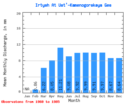
| Statistic | Jan | Feb | Mar | Apr | May | Jun | Jul | Aug | Sep | Oct | Nov | Dec | Annual |
|---|---|---|---|---|---|---|---|---|---|---|---|---|---|
| Mean | 0.86 | 6.22 | 8.05 | 11.21 | 9.08 | 9.92 | 9.99 | 9.91 | 9.97 | 8.67 | 8.64 | ||
| Standard Deviation | 0.46 | 1.89 | 4.79 | 3.54 | 1.68 | 1.54 | 1.77 | 1.88 | 1.69 | 1.89 | 2.82 | ||
| Min | 0.03 | 4.14 | 0.89 | 4.38 | 4.79 | 6.92 | 6.95 | 6.69 | 7.01 | 5.84 | 4.37 | ||
| Max | 1.50 | 12.05 | 16.32 | 17.76 | 13.15 | 13.70 | 13.54 | 14.24 | 14.09 | 12.85 | 15.54 | ||
| Coefficient of Variation | 0.53 | 0.30 | 0.59 | 0.32 | 0.18 | 0.15 | 0.18 | 0.19 | 0.17 | 0.22 | 0.33 |
 Return to R-Arctic Net Home Page