|
|
|||||||||||||||||
| Point ID: 8541 | Downloads | Plots | Site Data | Code: 11006 |
|
|
|||||||||||||||||
| Download | |
|---|---|
| Site Descriptor Information | Site Time Series Data |
| Link to all available data | |
| View: | Time Series | All |
| Units: | mm |
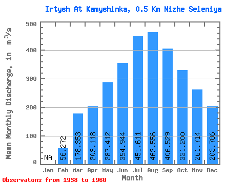
| Statistic | Jan | Feb | Mar | Apr | May | Jun | Jul | Aug | Sep | Oct | Nov | Dec | Annual |
|---|---|---|---|---|---|---|---|---|---|---|---|---|---|
| Mean | 56.27 | 178.35 | 203.12 | 287.41 | 354.94 | 451.61 | 462.56 | 406.53 | 331.20 | 261.71 | 203.79 | ||
| Standard Deviation | 29.73 | 46.59 | 45.94 | 67.31 | 71.70 | 109.37 | 144.41 | 127.20 | 103.95 | 82.63 | 66.49 | ||
| Min | 12.00 | 108.00 | 148.00 | 187.00 | 210.00 | 210.00 | 190.00 | 182.00 | 171.00 | 160.00 | 135.00 | ||
| Max | 98.00 | 291.00 | 317.00 | 430.00 | 473.00 | 651.00 | 772.00 | 737.00 | 617.00 | 470.00 | 373.00 | ||
| Coefficient of Variation | 0.53 | 0.26 | 0.23 | 0.23 | 0.20 | 0.24 | 0.31 | 0.31 | 0.31 | 0.32 | 0.33 |
 Return to R-Arctic Net Home Page