|
|
|||||||||||||||||
| Point ID: 8541 | Downloads | Plots | Site Data | Code: 11006 |
|
|
|||||||||||||||||
| Download | |
|---|---|
| Site Descriptor Information | Site Time Series Data |
| Link to all available data | |
| View: | Time Series | All |
| Units: | m3/s |
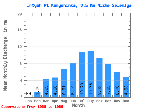
| Statistic | Jan | Feb | Mar | Apr | May | Jun | Jul | Aug | Sep | Oct | Nov | Dec | Annual |
|---|---|---|---|---|---|---|---|---|---|---|---|---|---|
| Mean | 1.22 | 4.23 | 4.66 | 6.81 | 8.14 | 10.70 | 10.96 | 9.32 | 7.85 | 6.00 | 4.83 | ||
| Standard Deviation | 0.64 | 1.10 | 1.05 | 1.59 | 1.65 | 2.59 | 3.42 | 2.92 | 2.46 | 1.90 | 1.58 | ||
| Min | 0.26 | 2.56 | 3.40 | 4.43 | 4.82 | 4.98 | 4.50 | 4.17 | 4.05 | 3.67 | 3.20 | ||
| Max | 2.12 | 6.90 | 7.27 | 10.19 | 10.85 | 15.43 | 18.30 | 16.91 | 14.62 | 10.78 | 8.84 | ||
| Coefficient of Variation | 0.53 | 0.26 | 0.23 | 0.23 | 0.20 | 0.24 | 0.31 | 0.31 | 0.31 | 0.32 | 0.33 |
 Return to R-Arctic Net Home Page