|
|
|||||||||||||||||
| Point ID: 8507 | Downloads | Plots | Site Data | Code: 10469 |
|
|
|||||||||||||||||
| Download | |
|---|---|
| Site Descriptor Information | Site Time Series Data |
| Link to all available data | |
| View: | Time Series | All |
| Units: | mm |
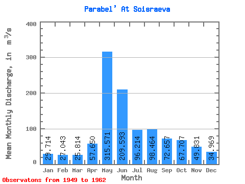
| Statistic | Jan | Feb | Mar | Apr | May | Jun | Jul | Aug | Sep | Oct | Nov | Dec | Annual |
|---|---|---|---|---|---|---|---|---|---|---|---|---|---|
| Mean | 29.71 | 27.04 | 25.81 | 57.65 | 315.57 | 209.59 | 96.21 | 98.46 | 72.66 | 67.71 | 49.83 | 34.97 | 87.56 |
| Standard Deviation | 5.45 | 3.63 | 3.04 | 41.10 | 102.55 | 113.63 | 41.81 | 64.45 | 51.15 | 30.55 | 20.93 | 9.88 | 27.86 |
| Min | 22.60 | 20.10 | 20.70 | 25.70 | 159.00 | 89.10 | 36.50 | 33.40 | 34.90 | 35.80 | 27.60 | 24.60 | 52.02 |
| Max | 43.80 | 34.00 | 30.40 | 168.00 | 507.00 | 447.00 | 179.00 | 211.00 | 231.00 | 131.00 | 89.30 | 57.00 | 133.48 |
| Coefficient of Variation | 0.18 | 0.13 | 0.12 | 0.71 | 0.33 | 0.54 | 0.43 | 0.66 | 0.70 | 0.45 | 0.42 | 0.28 | 0.32 |
 Return to R-Arctic Net Home Page