|
|
|||||||||||||||||
| Point ID: 8507 | Downloads | Plots | Site Data | Code: 10469 |
|
|
|||||||||||||||||
| Download | |
|---|---|
| Site Descriptor Information | Site Time Series Data |
| Link to all available data | |
| View: | Time Series | All |
| Units: | m3/s |
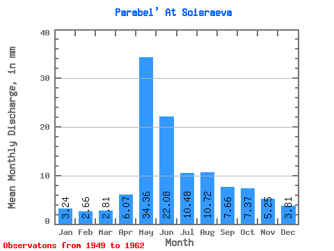
| Statistic | Jan | Feb | Mar | Apr | May | Jun | Jul | Aug | Sep | Oct | Nov | Dec | Annual |
|---|---|---|---|---|---|---|---|---|---|---|---|---|---|
| Mean | 3.23 | 2.68 | 2.81 | 6.07 | 34.35 | 22.08 | 10.47 | 10.72 | 7.66 | 7.37 | 5.25 | 3.81 | 112.34 |
| Standard Deviation | 0.59 | 0.36 | 0.33 | 4.33 | 11.16 | 11.97 | 4.55 | 7.02 | 5.39 | 3.33 | 2.21 | 1.07 | 35.74 |
| Min | 2.46 | 1.99 | 2.25 | 2.71 | 17.31 | 9.39 | 3.97 | 3.64 | 3.68 | 3.90 | 2.91 | 2.68 | 66.74 |
| Max | 4.77 | 3.37 | 3.31 | 17.70 | 55.19 | 47.10 | 19.49 | 22.97 | 24.34 | 14.26 | 9.41 | 6.21 | 171.25 |
| Coefficient of Variation | 0.18 | 0.13 | 0.12 | 0.71 | 0.33 | 0.54 | 0.43 | 0.66 | 0.70 | 0.45 | 0.42 | 0.28 | 0.32 |
 Return to R-Arctic Net Home Page