|
|
|||||||||||||||||
| Point ID: 8494 | Downloads | Plots | Site Data | Code: 10403 |
|
|
|||||||||||||||||
| Download | |
|---|---|
| Site Descriptor Information | Site Time Series Data |
| Link to all available data | |
| View: | Time Series | All |
| Units: | mm |
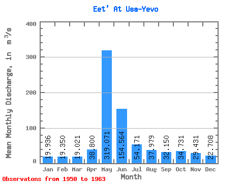
| Statistic | Jan | Feb | Mar | Apr | May | Jun | Jul | Aug | Sep | Oct | Nov | Dec | Annual |
|---|---|---|---|---|---|---|---|---|---|---|---|---|---|
| Mean | 19.94 | 19.35 | 19.02 | 38.80 | 319.07 | 154.56 | 54.17 | 37.98 | 32.15 | 34.73 | 29.43 | 22.71 | 66.29 |
| Standard Deviation | 2.08 | 2.38 | 2.12 | 29.16 | 66.25 | 62.39 | 18.01 | 11.42 | 5.40 | 11.47 | 6.64 | 3.32 | 9.85 |
| Min | 17.00 | 15.40 | 14.50 | 22.10 | 234.00 | 69.10 | 33.00 | 28.90 | 25.00 | 25.20 | 19.90 | 17.90 | 49.09 |
| Max | 23.30 | 22.30 | 22.10 | 129.00 | 446.00 | 255.00 | 100.00 | 68.40 | 39.40 | 66.50 | 41.00 | 29.40 | 83.92 |
| Coefficient of Variation | 0.10 | 0.12 | 0.11 | 0.75 | 0.21 | 0.40 | 0.33 | 0.30 | 0.17 | 0.33 | 0.23 | 0.15 | 0.15 |
 Return to R-Arctic Net Home Page