|
|
|||||||||||||||||
| Point ID: 8494 | Downloads | Plots | Site Data | Code: 10403 |
|
|
|||||||||||||||||
| Download | |
|---|---|
| Site Descriptor Information | Site Time Series Data |
| Link to all available data | |
| View: | Time Series | All |
| Units: | m3/s |
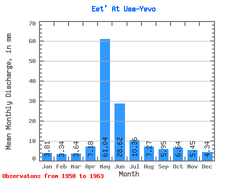
| Statistic | Jan | Feb | Mar | Apr | May | Jun | Jul | Aug | Sep | Oct | Nov | Dec | Annual |
|---|---|---|---|---|---|---|---|---|---|---|---|---|---|
| Mean | 3.81 | 3.37 | 3.64 | 7.18 | 61.03 | 28.62 | 10.36 | 7.26 | 5.95 | 6.64 | 5.45 | 4.34 | 149.43 |
| Standard Deviation | 0.40 | 0.41 | 0.41 | 5.40 | 12.67 | 11.55 | 3.44 | 2.19 | 1.00 | 2.19 | 1.23 | 0.64 | 22.20 |
| Min | 3.25 | 2.68 | 2.77 | 4.09 | 44.76 | 12.79 | 6.31 | 5.53 | 4.63 | 4.82 | 3.68 | 3.42 | 110.67 |
| Max | 4.46 | 3.89 | 4.23 | 23.88 | 85.31 | 47.21 | 19.13 | 13.08 | 7.29 | 12.72 | 7.59 | 5.62 | 189.19 |
| Coefficient of Variation | 0.10 | 0.12 | 0.11 | 0.75 | 0.21 | 0.40 | 0.33 | 0.30 | 0.17 | 0.33 | 0.23 | 0.15 | 0.15 |
 Return to R-Arctic Net Home Page