|
|
|||||||||||||||||
| Point ID: 8381 | Downloads | Plots | Site Data | Code: 9466 |
|
|
|||||||||||||||||
| Download | |
|---|---|
| Site Descriptor Information | Site Time Series Data |
| Link to all available data | |
| View: | Time Series | All |
| Units: | mm |
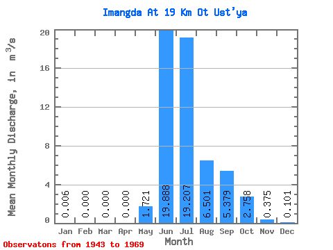
| Statistic | Jan | Feb | Mar | Apr | May | Jun | Jul | Aug | Sep | Oct | Nov | Dec | Annual |
|---|---|---|---|---|---|---|---|---|---|---|---|---|---|
| Mean | 0.01 | 0.00 | 0.00 | 0.00 | 1.72 | 19.89 | 19.21 | 6.50 | 5.38 | 2.76 | 0.38 | 0.10 | 4.57 |
| Standard Deviation | 0.01 | 0.00 | 0.00 | 0.00 | 3.28 | 5.92 | 11.18 | 2.63 | 2.03 | 2.42 | 0.28 | 0.12 | 0.56 |
| Min | 0.00 | 0.00 | 0.00 | 0.00 | 0.00 | 11.80 | 4.76 | 1.91 | 3.26 | 0.41 | 0.00 | 0.00 | 3.77 |
| Max | 0.04 | 0.00 | 0.00 | 0.00 | 9.66 | 28.10 | 41.10 | 10.70 | 8.75 | 6.77 | 0.71 | 0.30 | 5.69 |
| Coefficient of Variation | 2.23 | 1.90 | 0.30 | 0.58 | 0.40 | 0.38 | 0.88 | 0.74 | 1.15 | 0.12 |
 Return to R-Arctic Net Home Page