|
|
|||||||||||||||||
| Point ID: 8381 | Downloads | Plots | Site Data | Code: 9466 |
|
|
|||||||||||||||||
| Download | |
|---|---|
| Site Descriptor Information | Site Time Series Data |
| Link to all available data | |
| View: | Time Series | All |
| Units: | m3/s |
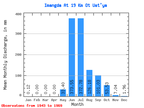
| Statistic | Jan | Feb | Mar | Apr | May | Jun | Jul | Aug | Sep | Oct | Nov | Dec | Annual |
|---|---|---|---|---|---|---|---|---|---|---|---|---|---|
| Mean | 0.12 | 0.00 | 0.00 | 0.00 | 33.41 | 373.54 | 372.72 | 126.16 | 101.03 | 53.52 | 7.04 | 1.96 | 1044.76 |
| Standard Deviation | 0.26 | 0.00 | 0.00 | 0.00 | 63.60 | 111.24 | 216.89 | 50.95 | 38.08 | 47.05 | 5.22 | 2.25 | 129.13 |
| Min | 0.00 | 0.00 | 0.00 | 0.00 | 0.00 | 221.63 | 92.37 | 37.06 | 61.23 | 7.96 | 0.04 | 0.00 | 863.17 |
| Max | 0.74 | 0.00 | 0.00 | 0.00 | 187.46 | 527.79 | 797.58 | 207.64 | 164.35 | 131.38 | 13.34 | 5.82 | 1300.72 |
| Coefficient of Variation | 2.23 | 1.90 | 0.30 | 0.58 | 0.40 | 0.38 | 0.88 | 0.74 | 1.15 | 0.12 |
 Return to R-Arctic Net Home Page