|
|
|||||||||||||||||
| Point ID: 8355 | Downloads | Plots | Site Data | Code: 9332 |
|
|
|||||||||||||||||
| Download | |
|---|---|
| Site Descriptor Information | Site Time Series Data |
| Link to all available data | |
| View: | Time Series | All |
| Units: | mm |
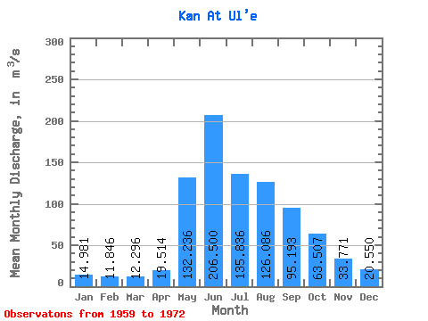
| Statistic | Jan | Feb | Mar | Apr | May | Jun | Jul | Aug | Sep | Oct | Nov | Dec | Annual |
|---|---|---|---|---|---|---|---|---|---|---|---|---|---|
| Mean | 14.98 | 11.85 | 12.30 | 19.51 | 132.24 | 206.50 | 135.84 | 126.09 | 95.19 | 63.51 | 33.77 | 20.55 | 72.69 |
| Standard Deviation | 4.63 | 3.46 | 1.94 | 4.93 | 42.98 | 77.42 | 35.53 | 43.58 | 23.46 | 16.78 | 5.94 | 5.09 | 13.44 |
| Min | 8.61 | 7.27 | 9.55 | 12.20 | 67.30 | 129.00 | 72.80 | 71.10 | 62.80 | 42.00 | 24.00 | 13.60 | 52.51 |
| Max | 23.70 | 19.00 | 15.80 | 29.80 | 221.00 | 388.00 | 193.00 | 235.00 | 135.00 | 103.00 | 42.70 | 32.50 | 104.85 |
| Coefficient of Variation | 0.31 | 0.29 | 0.16 | 0.25 | 0.33 | 0.38 | 0.26 | 0.35 | 0.25 | 0.26 | 0.18 | 0.25 | 0.18 |
 Return to R-Arctic Net Home Page