|
|
|||||||||||||||||
| Point ID: 8355 | Downloads | Plots | Site Data | Code: 9332 |
|
|
|||||||||||||||||
| Download | |
|---|---|
| Site Descriptor Information | Site Time Series Data |
| Link to all available data | |
| View: | Time Series | All |
| Units: | m3/s |
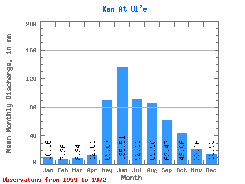
| Statistic | Jan | Feb | Mar | Apr | May | Jun | Jul | Aug | Sep | Oct | Nov | Dec | Annual |
|---|---|---|---|---|---|---|---|---|---|---|---|---|---|
| Mean | 10.16 | 7.32 | 8.34 | 12.80 | 89.65 | 135.51 | 92.09 | 85.48 | 62.47 | 43.06 | 22.16 | 13.93 | 580.81 |
| Standard Deviation | 3.14 | 2.14 | 1.32 | 3.24 | 29.14 | 50.80 | 24.09 | 29.55 | 15.39 | 11.38 | 3.90 | 3.45 | 107.39 |
| Min | 5.84 | 4.49 | 6.47 | 8.01 | 45.63 | 84.65 | 49.36 | 48.20 | 41.21 | 28.48 | 15.75 | 9.22 | 419.53 |
| Max | 16.07 | 11.74 | 10.71 | 19.55 | 149.83 | 254.61 | 130.85 | 159.32 | 88.59 | 69.83 | 28.02 | 22.03 | 837.73 |
| Coefficient of Variation | 0.31 | 0.29 | 0.16 | 0.25 | 0.33 | 0.38 | 0.26 | 0.35 | 0.25 | 0.26 | 0.18 | 0.25 | 0.18 |
 Return to R-Arctic Net Home Page