|
|
|||||||||||||||||
| Point ID: 8349 | Downloads | Plots | Site Data | Code: 9318 |
|
|
|||||||||||||||||
| Download | |
|---|---|
| Site Descriptor Information | Site Time Series Data |
| Link to all available data | |
| View: | Time Series | All |
| Units: | mm |
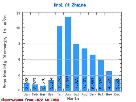
| Statistic | Jan | Feb | Mar | Apr | May | Jun | Jul | Aug | Sep | Oct | Nov | Dec | Annual |
|---|---|---|---|---|---|---|---|---|---|---|---|---|---|
| Mean | 3.03 | 2.83 | 2.68 | 3.37 | 10.21 | 11.39 | 7.92 | 7.41 | 6.59 | 5.88 | 4.54 | 3.53 | 5.75 |
| Standard Deviation | 0.41 | 0.67 | 0.42 | 0.98 | 1.47 | 4.66 | 2.05 | 1.94 | 1.42 | 0.89 | 0.90 | 0.57 | 0.75 |
| Min | 2.38 | 2.14 | 2.09 | 2.11 | 7.14 | 5.71 | 5.62 | 4.92 | 4.86 | 4.47 | 3.04 | 2.38 | 4.54 |
| Max | 3.87 | 4.48 | 3.71 | 5.12 | 12.60 | 21.80 | 12.20 | 11.20 | 9.71 | 7.13 | 6.55 | 4.50 | 7.16 |
| Coefficient of Variation | 0.14 | 0.24 | 0.16 | 0.29 | 0.14 | 0.41 | 0.26 | 0.26 | 0.21 | 0.15 | 0.20 | 0.16 | 0.13 |
 Return to R-Arctic Net Home Page