|
|
|||||||||||||||||
| Point ID: 8349 | Downloads | Plots | Site Data | Code: 9318 |
|
|
|||||||||||||||||
| Download | |
|---|---|
| Site Descriptor Information | Site Time Series Data |
| Link to all available data | |
| View: | Time Series | All |
| Units: | m3/s |
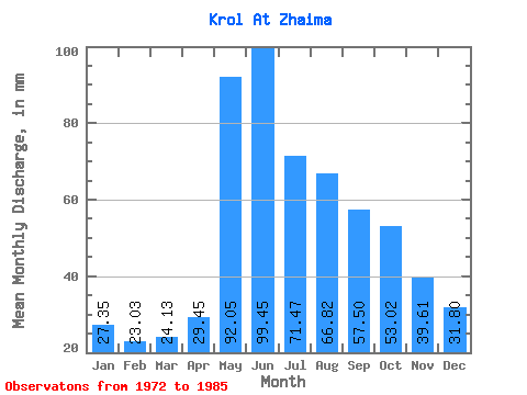
| Statistic | Jan | Feb | Mar | Apr | May | Jun | Jul | Aug | Sep | Oct | Nov | Dec | Annual |
|---|---|---|---|---|---|---|---|---|---|---|---|---|---|
| Mean | 27.35 | 23.23 | 24.13 | 29.44 | 92.03 | 99.44 | 71.45 | 66.80 | 57.51 | 53.01 | 39.62 | 31.80 | 611.10 |
| Standard Deviation | 3.73 | 5.49 | 3.83 | 8.60 | 13.29 | 40.68 | 18.47 | 17.52 | 12.39 | 7.98 | 7.84 | 5.17 | 79.72 |
| Min | 21.46 | 17.58 | 18.84 | 18.41 | 64.38 | 49.83 | 50.67 | 44.36 | 42.41 | 40.30 | 26.53 | 21.46 | 482.70 |
| Max | 34.90 | 36.80 | 33.45 | 44.68 | 113.61 | 190.25 | 110.00 | 100.99 | 84.74 | 64.29 | 57.16 | 40.58 | 760.31 |
| Coefficient of Variation | 0.14 | 0.24 | 0.16 | 0.29 | 0.14 | 0.41 | 0.26 | 0.26 | 0.21 | 0.15 | 0.20 | 0.16 | 0.13 |
 Return to R-Arctic Net Home Page