|
|
|||||||||||||||||
| Point ID: 8342 | Downloads | Plots | Site Data | Code: 9304 |
|
|
|||||||||||||||||
| Download | |
|---|---|
| Site Descriptor Information | Site Time Series Data |
| Link to all available data | |
| View: | Time Series | All |
| Units: | mm |
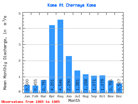
| Statistic | Jan | Feb | Mar | Apr | May | Jun | Jul | Aug | Sep | Oct | Nov | Dec | Annual |
|---|---|---|---|---|---|---|---|---|---|---|---|---|---|
| Mean | 0.50 | 0.46 | 0.79 | 4.20 | 4.55 | 2.29 | 1.38 | 1.16 | 1.07 | 1.08 | 0.76 | 0.59 | 1.57 |
| Standard Deviation | 0.19 | 0.15 | 0.39 | 1.74 | 3.64 | 1.39 | 0.68 | 0.40 | 0.29 | 0.30 | 0.25 | 0.24 | 0.55 |
| Min | 0.21 | 0.14 | 0.41 | 1.89 | 1.87 | 1.14 | 0.12 | 0.61 | 0.69 | 0.65 | 0.35 | 0.12 | 0.83 |
| Max | 0.82 | 0.76 | 1.66 | 7.77 | 19.30 | 6.62 | 2.93 | 2.17 | 1.91 | 1.72 | 1.21 | 0.99 | 3.23 |
| Coefficient of Variation | 0.37 | 0.33 | 0.49 | 0.41 | 0.80 | 0.61 | 0.49 | 0.34 | 0.27 | 0.28 | 0.33 | 0.40 | 0.35 |
 Return to R-Arctic Net Home Page