|
|
|||||||||||||||||
| Point ID: 8342 | Downloads | Plots | Site Data | Code: 9304 |
|
|
|||||||||||||||||
| Download | |
|---|---|
| Site Descriptor Information | Site Time Series Data |
| Link to all available data | |
| View: | Time Series | All |
| Units: | m3/s |
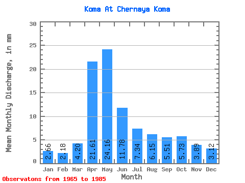
| Statistic | Jan | Feb | Mar | Apr | May | Jun | Jul | Aug | Sep | Oct | Nov | Dec | Annual |
|---|---|---|---|---|---|---|---|---|---|---|---|---|---|
| Mean | 2.66 | 2.20 | 4.21 | 21.61 | 24.16 | 11.78 | 7.34 | 6.15 | 5.51 | 5.73 | 3.89 | 3.12 | 98.18 |
| Standard Deviation | 0.99 | 0.73 | 2.06 | 8.96 | 19.34 | 7.13 | 3.61 | 2.10 | 1.50 | 1.62 | 1.28 | 1.25 | 34.67 |
| Min | 1.12 | 0.68 | 2.18 | 9.72 | 9.94 | 5.86 | 0.66 | 3.24 | 3.55 | 3.46 | 1.80 | 0.64 | 51.92 |
| Max | 4.36 | 3.68 | 8.82 | 39.96 | 102.55 | 34.05 | 15.57 | 11.53 | 9.82 | 9.14 | 6.22 | 5.26 | 202.00 |
| Coefficient of Variation | 0.37 | 0.33 | 0.49 | 0.41 | 0.80 | 0.61 | 0.49 | 0.34 | 0.27 | 0.28 | 0.33 | 0.40 | 0.35 |
 Return to R-Arctic Net Home Page