|
|
|||||||||||||||||
| Point ID: 8216 | Downloads | Plots | Site Data | Code: 8243 |
|
|
|||||||||||||||||
| Download | |
|---|---|
| Site Descriptor Information | Site Time Series Data |
| Link to all available data | |
| View: | Time Series | All |
| Units: | mm |
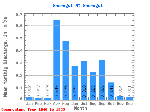
| Statistic | Jan | Feb | Mar | Apr | May | Jun | Jul | Aug | Sep | Oct | Nov | Dec | Annual |
|---|---|---|---|---|---|---|---|---|---|---|---|---|---|
| Mean | 0.02 | 0.02 | 0.02 | 0.65 | 0.47 | 0.27 | 0.32 | 0.23 | 0.33 | 0.14 | 0.03 | 0.02 | 0.21 |
| Standard Deviation | 0.01 | 0.01 | 0.01 | 0.64 | 0.31 | 0.25 | 0.25 | 0.19 | 0.36 | 0.08 | 0.01 | 0.01 | 0.13 |
| Min | 0.01 | 0.00 | 0.01 | 0.07 | 0.18 | 0.10 | 0.07 | 0.07 | 0.06 | 0.05 | 0.02 | 0.01 | 0.09 |
| Max | 0.04 | 0.03 | 0.03 | 1.61 | 1.08 | 0.90 | 0.80 | 0.59 | 0.94 | 0.31 | 0.06 | 0.04 | 0.39 |
| Coefficient of Variation | 0.46 | 0.49 | 0.48 | 0.98 | 0.66 | 0.90 | 0.80 | 0.84 | 1.09 | 0.56 | 0.40 | 0.53 | 0.60 |
 Return to R-Arctic Net Home Page