|
|
|||||||||||||||||
| Point ID: 8216 | Downloads | Plots | Site Data | Code: 8243 |
|
|
|||||||||||||||||
| Download | |
|---|---|
| Site Descriptor Information | Site Time Series Data |
| Link to all available data | |
| View: | Time Series | All |
| Units: | m3/s |
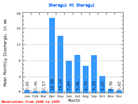
| Statistic | Jan | Feb | Mar | Apr | May | Jun | Jul | Aug | Sep | Oct | Nov | Dec | Annual |
|---|---|---|---|---|---|---|---|---|---|---|---|---|---|
| Mean | 0.66 | 0.47 | 0.58 | 18.59 | 14.13 | 7.90 | 9.45 | 6.68 | 9.39 | 4.18 | 0.98 | 0.64 | 74.00 |
| Standard Deviation | 0.30 | 0.23 | 0.28 | 18.28 | 9.33 | 7.11 | 7.55 | 5.63 | 10.27 | 2.36 | 0.39 | 0.34 | 44.48 |
| Min | 0.18 | 0.11 | 0.27 | 1.87 | 5.36 | 2.74 | 1.99 | 2.02 | 1.76 | 1.61 | 0.46 | 0.21 | 31.50 |
| Max | 1.22 | 0.90 | 1.01 | 46.37 | 32.14 | 25.92 | 23.80 | 17.56 | 27.07 | 9.22 | 1.61 | 1.22 | 138.09 |
| Coefficient of Variation | 0.46 | 0.49 | 0.48 | 0.98 | 0.66 | 0.90 | 0.80 | 0.84 | 1.09 | 0.56 | 0.40 | 0.53 | 0.60 |
 Return to R-Arctic Net Home Page