|
|
|||||||||||||||||
| Point ID: 8211 | Downloads | Plots | Site Data | Code: 8222 |
|
|
|||||||||||||||||
| Download | |
|---|---|
| Site Descriptor Information | Site Time Series Data |
| Link to all available data | |
| View: | Time Series | All |
| Units: | mm |
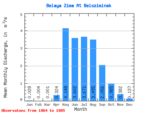
| Statistic | Jan | Feb | Mar | Apr | May | Jun | Jul | Aug | Sep | Oct | Nov | Dec | Annual |
|---|---|---|---|---|---|---|---|---|---|---|---|---|---|
| Mean | 0.03 | 0.00 | 0.00 | 0.32 | 4.15 | 3.60 | 3.67 | 3.50 | 2.06 | 0.98 | 0.38 | 0.14 | 1.57 |
| Standard Deviation | 0.03 | 0.01 | 0.00 | 0.39 | 2.09 | 1.67 | 1.79 | 1.83 | 1.03 | 0.45 | 0.15 | 0.07 | 0.35 |
| Min | 0.00 | 0.00 | 0.00 | 0.00 | 1.57 | 1.10 | 1.51 | 1.62 | 0.95 | 0.39 | 0.10 | 0.00 | 0.91 |
| Max | 0.12 | 0.04 | 0.02 | 1.24 | 10.10 | 8.24 | 9.16 | 7.64 | 5.23 | 2.24 | 0.70 | 0.25 | 2.16 |
| Coefficient of Variation | 1.10 | 2.48 | 4.58 | 1.21 | 0.50 | 0.46 | 0.49 | 0.53 | 0.50 | 0.46 | 0.39 | 0.51 | 0.22 |
 Return to R-Arctic Net Home Page