|
|
|||||||||||||||||
| Point ID: 8211 | Downloads | Plots | Site Data | Code: 8222 |
|
|
|||||||||||||||||
| Download | |
|---|---|
| Site Descriptor Information | Site Time Series Data |
| Link to all available data | |
| View: | Time Series | All |
| Units: | m3/s |
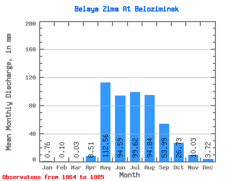
| Statistic | Jan | Feb | Mar | Apr | May | Jun | Jul | Aug | Sep | Oct | Nov | Dec | Annual |
|---|---|---|---|---|---|---|---|---|---|---|---|---|---|
| Mean | 0.77 | 0.10 | 0.02 | 8.51 | 112.55 | 94.60 | 99.60 | 94.82 | 54.00 | 26.74 | 10.04 | 3.71 | 503.31 |
| Standard Deviation | 0.84 | 0.24 | 0.10 | 10.28 | 56.77 | 43.75 | 48.62 | 49.80 | 27.15 | 12.29 | 3.89 | 1.88 | 110.52 |
| Min | 0.00 | 0.00 | 0.00 | 0.00 | 42.60 | 28.89 | 40.97 | 43.95 | 24.95 | 10.58 | 2.60 | 0.11 | 291.00 |
| Max | 3.26 | 0.92 | 0.43 | 32.56 | 274.04 | 216.39 | 248.54 | 207.29 | 137.35 | 60.78 | 18.38 | 6.78 | 689.61 |
| Coefficient of Variation | 1.10 | 2.48 | 4.58 | 1.21 | 0.50 | 0.46 | 0.49 | 0.53 | 0.50 | 0.46 | 0.39 | 0.51 | 0.22 |
 Return to R-Arctic Net Home Page