|
|
|||||||||||||||||
| Point ID: 8206 | Downloads | Plots | Site Data | Code: 8214 |
|
|
|||||||||||||||||
| Download | |
|---|---|
| Site Descriptor Information | Site Time Series Data |
| Link to all available data | |
| View: | Time Series | All |
| Units: | mm |
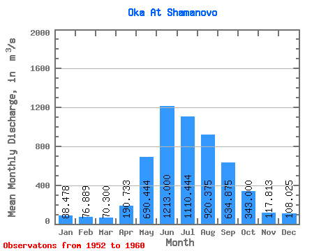
| Statistic | Jan | Feb | Mar | Apr | May | Jun | Jul | Aug | Sep | Oct | Nov | Dec | Annual |
|---|---|---|---|---|---|---|---|---|---|---|---|---|---|
| Mean | 88.48 | 76.89 | 70.30 | 190.73 | 690.44 | 1213.00 | 1110.44 | 920.38 | 634.88 | 343.00 | 117.81 | 108.03 | 464.36 |
| Standard Deviation | 11.14 | 9.63 | 9.82 | 99.46 | 154.18 | 301.64 | 375.76 | 144.68 | 115.64 | 52.93 | 12.69 | 11.01 | 68.16 |
| Min | 73.20 | 62.40 | 57.00 | 89.90 | 509.00 | 846.00 | 581.00 | 740.00 | 451.00 | 287.00 | 89.50 | 95.20 | 404.13 |
| Max | 110.00 | 92.60 | 87.70 | 395.00 | 989.00 | 1680.00 | 1860.00 | 1190.00 | 788.00 | 438.00 | 128.00 | 125.00 | 607.44 |
| Coefficient of Variation | 0.13 | 0.12 | 0.14 | 0.52 | 0.22 | 0.25 | 0.34 | 0.16 | 0.18 | 0.15 | 0.11 | 0.10 | 0.15 |
 Return to R-Arctic Net Home Page