|
|
|||||||||||||||||
| Point ID: 8206 | Downloads | Plots | Site Data | Code: 8214 |
|
|
|||||||||||||||||
| Download | |
|---|---|
| Site Descriptor Information | Site Time Series Data |
| Link to all available data | |
| View: | Time Series | All |
| Units: | m3/s |
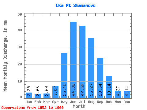
| Statistic | Jan | Feb | Mar | Apr | May | Jun | Jul | Aug | Sep | Oct | Nov | Dec | Annual |
|---|---|---|---|---|---|---|---|---|---|---|---|---|---|
| Mean | 3.39 | 2.68 | 2.69 | 7.07 | 26.45 | 44.98 | 42.54 | 35.26 | 23.54 | 13.14 | 4.37 | 4.14 | 209.66 |
| Standard Deviation | 0.43 | 0.34 | 0.38 | 3.69 | 5.91 | 11.19 | 14.40 | 5.54 | 4.29 | 2.03 | 0.47 | 0.42 | 30.77 |
| Min | 2.80 | 2.18 | 2.18 | 3.33 | 19.50 | 31.37 | 22.26 | 28.35 | 16.72 | 11.00 | 3.32 | 3.65 | 182.47 |
| Max | 4.21 | 3.23 | 3.36 | 14.65 | 37.89 | 62.30 | 71.26 | 45.59 | 29.22 | 16.78 | 4.75 | 4.79 | 274.26 |
| Coefficient of Variation | 0.13 | 0.12 | 0.14 | 0.52 | 0.22 | 0.25 | 0.34 | 0.16 | 0.18 | 0.15 | 0.11 | 0.10 | 0.15 |
 Return to R-Arctic Net Home Page