|
|
|||||||||||||||||
| Point ID: 8204 | Downloads | Plots | Site Data | Code: 8200 |
|
|
|||||||||||||||||
| Download | |
|---|---|
| Site Descriptor Information | Site Time Series Data |
| Link to all available data | |
| View: | Time Series | All |
| Units: | mm |
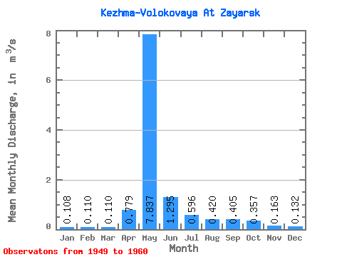
| Statistic | Jan | Feb | Mar | Apr | May | Jun | Jul | Aug | Sep | Oct | Nov | Dec | Annual |
|---|---|---|---|---|---|---|---|---|---|---|---|---|---|
| Mean | 0.11 | 0.11 | 0.11 | 0.78 | 7.84 | 1.29 | 0.60 | 0.42 | 0.41 | 0.36 | 0.16 | 0.13 | 0.99 |
| Standard Deviation | 0.04 | 0.04 | 0.04 | 1.46 | 2.78 | 0.59 | 0.38 | 0.14 | 0.11 | 0.08 | 0.03 | 0.04 | 0.23 |
| Min | 0.04 | 0.04 | 0.03 | 0.18 | 4.02 | 0.67 | 0.21 | 0.24 | 0.25 | 0.20 | 0.12 | 0.07 | 0.61 |
| Max | 0.17 | 0.17 | 0.16 | 4.90 | 12.20 | 2.30 | 1.39 | 0.68 | 0.60 | 0.50 | 0.23 | 0.21 | 1.38 |
| Coefficient of Variation | 0.39 | 0.35 | 0.39 | 1.87 | 0.35 | 0.46 | 0.64 | 0.32 | 0.27 | 0.23 | 0.20 | 0.31 | 0.23 |
 Return to R-Arctic Net Home Page