|
|
|||||||||||||||||
| Point ID: 8204 | Downloads | Plots | Site Data | Code: 8200 |
|
|
|||||||||||||||||
| Download | |
|---|---|
| Site Descriptor Information | Site Time Series Data |
| Link to all available data | |
| View: | Time Series | All |
| Units: | m3/s |
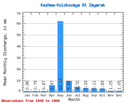
| Statistic | Jan | Feb | Mar | Apr | May | Jun | Jul | Aug | Sep | Oct | Nov | Dec | Annual |
|---|---|---|---|---|---|---|---|---|---|---|---|---|---|
| Mean | 0.85 | 0.79 | 0.87 | 5.97 | 62.09 | 9.93 | 4.72 | 3.33 | 3.11 | 2.83 | 1.25 | 1.04 | 92.20 |
| Standard Deviation | 0.33 | 0.28 | 0.34 | 11.16 | 22.01 | 4.56 | 3.01 | 1.07 | 0.83 | 0.65 | 0.25 | 0.33 | 21.19 |
| Min | 0.32 | 0.28 | 0.24 | 1.38 | 31.85 | 5.14 | 1.66 | 1.90 | 1.92 | 1.58 | 0.93 | 0.53 | 56.73 |
| Max | 1.35 | 1.23 | 1.27 | 37.58 | 96.66 | 17.64 | 11.01 | 5.39 | 4.60 | 3.96 | 1.76 | 1.66 | 128.78 |
| Coefficient of Variation | 0.39 | 0.35 | 0.39 | 1.87 | 0.35 | 0.46 | 0.64 | 0.32 | 0.27 | 0.23 | 0.20 | 0.31 | 0.23 |
 Return to R-Arctic Net Home Page