|
|
|||||||||||||||||
| Point ID: 8200 | Downloads | Plots | Site Data | Code: 8195 |
|
|
|||||||||||||||||
| Download | |
|---|---|
| Site Descriptor Information | Site Time Series Data |
| Link to all available data | |
| View: | Time Series | All |
| Units: | mm |
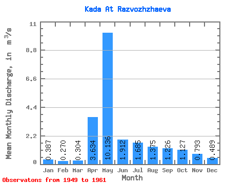
| Statistic | Jan | Feb | Mar | Apr | May | Jun | Jul | Aug | Sep | Oct | Nov | Dec | Annual |
|---|---|---|---|---|---|---|---|---|---|---|---|---|---|
| Mean | 0.39 | 0.27 | 0.30 | 3.63 | 10.14 | 1.91 | 1.69 | 1.38 | 1.23 | 1.13 | 0.79 | 0.49 | 1.99 |
| Standard Deviation | 0.25 | 0.22 | 0.22 | 2.50 | 5.62 | 0.82 | 1.04 | 0.49 | 0.50 | 0.41 | 0.28 | 0.16 | 0.54 |
| Min | 0.10 | 0.03 | 0.01 | 0.95 | 3.86 | 0.84 | 0.56 | 0.90 | 0.77 | 0.70 | 0.57 | 0.25 | 1.33 |
| Max | 0.98 | 0.74 | 0.64 | 7.75 | 23.60 | 4.06 | 4.09 | 2.43 | 2.43 | 2.01 | 1.42 | 0.92 | 2.97 |
| Coefficient of Variation | 0.65 | 0.81 | 0.73 | 0.69 | 0.55 | 0.43 | 0.62 | 0.35 | 0.41 | 0.36 | 0.35 | 0.34 | 0.27 |
 Return to R-Arctic Net Home Page